Sipsey Wilderness Trails
The information provided here is from the book
Alabama Trails, written by Richard Huey.
Trail #200 (easy)
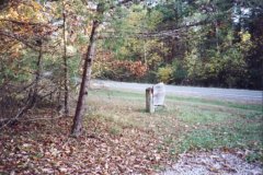
The trailhead for this wilderness trail is located at the eastern end of the bridge over
the Sipsey River on county road 60. It can be also hiked from the northern terminus on
Forest Road 224, where it crossed Borden Creek. (the road is closed to vehicles past the
bridge since the wilderness expansion)
From the parking area at the bridge, walk under the bridge to the trailhead. The trail
parallels the Sipsey River for the first .5 mile to where Borden Creek merges with the
Sipsey. Here, the trail bears right and follows Borden Creek NE. (Trail #209 begins across
the creek and follows the Sipsey River for nearly 7 miles, if you plan to cross to #209 be
prepared to get wet, Borden Creek is as big as the Sipsey River here) Continue along the
eastern bank of Borden Creek. At approximately 1.2 miles, the trail veers north for a
short distance before crossing an unnamed creek and heading W.
At approximately 1.7 miles, the trail veers north and passes along high bluffs and ledges
before ending near the bridge on FR 224. The end of the trail is more interesting than the
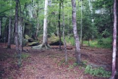
beginning, although it also becomes harder. At one point, the trail passes through a rock
formation, I found it easier to go over it, with packs on the cave would be impossible,
and I didn't want to get my pack muddy inside the cave, the climb over the cave is not
easy but, my girlfriend, with no climbing experience, made it over with a 40lb. pack on so
it can easily be done.
Trail #201 (easy)
This trail starts at the trailhead and parking area on county road 60 approximately 5
miles west of the Sipsey River Recreation Area.
From the trailhead, hike north for approximately .3 mile before reaching a junction with
Trail #202 (this trail leads NW approximately 2.9 miles, where it intersects with Trail
#209 on the Sipsey River).
Trail # 201 continues N for another 2 miles, where it intersects Trail #209 (this trail
descends approximately .5 mile to the Sipsey River and crosses before continuing SE for
another 6.5 miles).
At approximately 2.4 miles, just past the junction with Trail #209, the trail forks. The
right fork leads to a dead end on a bluff above the river. Bear left at the fork. The
trail soon descends along and around the ridge for another .5 mile before ending at the
Sipsey River. There is a small secluded campsite here.
Trail #202 (easy)
This trail leaves Trail #201 .3 mile from the trailhead and parking area on county road
60. From the junction, the trail wanders along a long ridge for approximately 2.5 miles.
The only interesting part of the trail is on old cemetery on your right approximately .8
mile from the start.
At approximately 2.5 miles, the trail descends to the Sipsey River. Cross the river and
pick up Trail #209 (again, crossing the river is not easy, especially during a period when
the rain index is high).
This trail, in combination with trails #209 and #201, provide a loop hike of approximately
10 miles.
Trail #204 (easy)
Like trail # 205, the trailhead for #204 is located in FR 224. When the Sipsey Wilderness
was expanded in 1988, this part of the road became inaccessible by motor vehicle. It is
approximately 4 miles to Thompson Creek on FR 224 & FR 208, and approximately 4 miles
to Borden Creek on FR 224.
The first .6 mile is a wide trail leading SE along the ridge. Here, the wide trail will
bear right, descending into the canyon. With a nice waterfall and the state's largest
tree, a 500 year old 150' poplar, it is easy to see why this canyon area has been so
popular for hikers. The trail into the canyon will parallel the creek and eventually
intersect Trail #209 and the Sipsey River.
The main trail becomes narrow and continues SE along the ridge for approximately .5 mile
before gradually descending and making several switchbacks around the ridge. At
approximately 2 miles, the trail descends beside a small waterfall and rockhouse on your
left. The next .4 mile continues to descend along the ridge before intersecting with trail
#209.
From the junction of trails #204 and #209, the hiker may continue W on trail #209 and N on
trail #206 to the Thompson Creek trailhead and parking area. A second option would be to
hike SE on trail #209 and then N on trail #200 to the bridge on Borden Creek and parking
area. Of course, the third option would be to hike SE on trail #209 and then N on trail
#200 to County Road 60 trailhead and parking area.
Trail #205 (easy)
The trailhead for this trail, like that of Trail #204, is located on FR 224. This area,
however, is inaccessible by motor vehicle since the Sipsey Wilderness expansion in 1988.
The closest parking area is FR 208 at Thompson Creek, which is 3 miles west of the
trailhead.
From FR 224, the trail basically follows the ridge line between White Oak Hollow and Bee
Branch Creek. The trail narrows a couple of times but for the most part, it is mainly a
wide trail and east to hike.
The last quarter mile is moderate descent down a rocky watershed to a junction with Trail
#206. This trail and Trail #206 could be used along with FR 208 for a loop hike.
Trail #206 (easy)
This trail follows Thompson Creek south, where it merges with several other creeks to form
the Sipsey River. The trailhead is located on FR 208, which runs along the northern edge
of the Sipsey Wilderness. (East of Thompson Creek is closed to vehicle traffic)
The trail runs south and parallels Thompson Creek briefly before turning E and crossing a
smaller creek. It then returns to parallel Thompson Creek with a rocky bluff on your left.
At approximately 1 mile, you reach an area on your right suitable for camping. A short
distance later, the trail turns E and crosses another small creek. At approximately 1.7
miles, the trail crosses a small creek area and cuts back SW. Here, a very short spur
trail ascends up to a waterfall and the rocky cliffs above the creek.
At approximately 2.5 mile, Quillian Creek (after merging earlier with Hubbard Creek)
merges with Thompson Creek to form the Sipsey River. Reach a small area at approximately
2.8 miles suitable for camping. At 2.9 mile, an unmarked (except for a scar on a tree on
your left) and hard to recognize trail on your left ascends up a rocky drainage to the
ridge above the canyon. (this is Trail #205, which follows the ridge to FR 224)
Just past this trail junction, you will intersect Trail #209. A signpost notates that
Trail #209 crosses the Sipsey River here en route to its junction with Trail #201. (Trail
#209 continues SE along the Sipsey River for approximately 6.5 miles) Trail #206 is a
great hike in Spring when the flowers are blooming. It can be hiked in conjunction with
the other trails to make a nice backpacking trip in the wilderness.
Trail #209 (easy)
This is the longest of the wilderness trails and perhaps the most interesting. The
southern terminus is located by hiking trail #200 north from the Sipsey River Recreation
Area on county road 60 for .5 mile. The northern terminus is located .5 mile west of the
Sipsey River at a junction with trail #201.
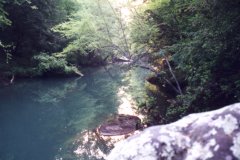
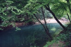
The trail follows the Sipsey River for 6.5 miles from Borden Creek before crossing the
river and ascending to its junction with Trail #201. Along the route, you will find
numerous side canyons, rock bluffs and waterfalls.
After crossing Borden Creek, the trail heads NW parallel to the river. At approximately .5
mile, reach a small canyon on your right, with a small campsite. Just ahead and near the
river is another campsite area. A short distance ahead, the trail will bear right before
crossing Fall Creek near a rockhouse and waterfall.
Approximately 1.2 miles, the trail passes along the base of the canyon wall and another
waterfall. At approximately 1.5 miles, the trail and river get farther away from the
canyon walls. After crossing a small creek, the trail continues far a short distance on an
old roadbed.
At 2.2 miles, cross another small creek. The trail and river soon turn SW at approximately
2.5 miles. Reach a campsite area large enough for a group on your right soon after the trail turns
SW, and another smaller campsite along the river ahead at 2.9 miles. At approximately 3
miles, the trail and river cut back to the NW. Pass by canyon walls for a short distance
before crossing a watershed on your right at approximately 3.6 miles. Here, the river
turns W.
At 4.1 miles, the river turns to the N. Reach a junction with Trail #202 at 4.4 miles (the
sign was missing, but the post was still in place). Trail #202 descends to the ridge top
across the river and winds SW for 2.9 miles to intersect Trail #201. There is another
small campsite near the trail junction and another just ahead a short distance.
Cross a creek at 5.1 miles, with a camping area just ahead. A small creek winds its way
through the lowland before entering the river.
Reach a junction with Trail #204 at 6 miles. (This trail ascends to the ridge and
continues NE along the ridge to its trailhead on FR 224. The popular Bee Branch area is
reached by taking this trail). Another campsite is located beside the river on your left.
At 6.5 miles, cross Bee Branch Creek, with campsites on each side of the junction with the
Sipsey River. The river quickly turns to the W for a short distance. Reach another
campsite area at 7 miles and also a campsite area at 7.5 miles, where the river turns S.
At 8 miles, cross a small creek and reach another campsite just ahead. At 8.5 miles, reach
a junction with Trail #206, which continues N for 2.9 miles to Thompson Creek bridge on FR
208. Trail #209 crosses the river here and continues on your right after crossing. (again
be prepared for crossing the river) The next .5 mile ascends before reaching Trail # 201.
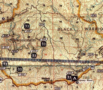
A new Trail Map is available for the Sipsey Wilderness.
This topographical map illustrates unmarked and maintained
trails in a useful scale.
If interested contact:

	Backcountry Trail Surveys
	PO Box 5224
	Huntsville, Al 35814
	trails@terragis.com